Advanced Search
Volume 43 Issue 1
Feb.  2025
Turn off MathJax
Article Contents

XIA Yong, HUI Xiao, ZHAO JunFeng, HOU YunChao, LI HuiQiong, BAI JinLi, LIU YongTao. Clinoform Growth and Its Controls on the Distribution of Sandstone in the Yanchang Formation, Qingcheng Area, Southwestern Ordos Basin[J]. Acta Sedimentologica Sinica, 2025, 43(1): 273-287. doi: 10.14027/j.issn.1000-0550.2022.150
Citation: XIA Yong, HUI Xiao, ZHAO JunFeng, HOU YunChao, LI HuiQiong, BAI JinLi, LIU YongTao. Clinoform Growth and Its Controls on the Distribution of Sandstone in the Yanchang Formation, Qingcheng Area, Southwestern Ordos Basin[J]. Acta Sedimentologica Sinica, 2025, 43(1): 273-287. doi: 10.14027/j.issn.1000-0550.2022.150

Clinoform Growth and Its Controls on the Distribution of Sandstone in the Yanchang Formation, Qingcheng Area, Southwestern Ordos Basin

doi: 10.14027/j.issn.1000-0550.2022.150
Funds:

National Natural Science Foundation of China 42172123

National Natural Science Foundation of China 42230815

  • Received Date: 2022-09-06
  • Accepted Date: 2023-02-09
  • Rev Recd Date: 2022-11-17
  • Available Online: 2023-02-09
  • Publish Date: 2025-02-10
  • Objective Clinoform growth is found in lacustrine or marine basins, and its growth mode reveals the changes of sediment supply, lake level, and deep-water sand delivery pattern. The typical clinoform growth styles are identified in the middle-upper Yanchang Formation based on newly obtained three-dimensional (3D) seismic data in the southwestern Ordos Basin. This discovery has changed the traditional understanding of the “flat-filling” deposition of the Yanchang Formation, provided a new idea for analyzing the distribution of sandstone and reservoir prediction from delta to deep-water area. Methods Based on the 3D seismic and drilling data from the Qingcheng area in the southwestern Ordos Basin, the middle-upper Yanchang Formation can be divided into six clinothems named F1⁃F6 respectively, guided by the clinoform growth theory. The characteristics of clinothems F1⁃F4 were described quantitatively, with relatively complete slope form. Results First, the results show that the four clinothems have similar morphological characteristics based on the representative seismic profiles in the study area. All four clinothems have lenticular external morphology and S-shaped internal reflection structure. Second, the sedimentary time span of one clinothem is approximately 4 to 6 million years. Third, clinothems F1⁃F4 can be quantitatively divided into two types, “thick-topset and thin-foreset” and “thin-topset and thick-foreset” based on the strata thickness. Clinothem F1 belongs to the former type, while the other three clinothems belong to the latter type. Fourth, two types of shoreline trajectories were identified, including flat of 0°⁃0.5° and slightly rising of 0.5°⁃1.0°. The trajectory angle of F2 is 0.366°⁃0.489° and the angle of F3 is 0.256°⁃0.275°. While the trajectory angle of F4 is 0.475°⁃0.673°, which has a slight increase compared with the previous period of F2 and F3. Moreover, the shoreline trajectories of F2 and F3 are flat, while the shoreline trajectories of F4 are slightly rising. Conclusions The lacustrine basin reached the largest extent in the F1 period, and aggradation dominated clinothems were formed with the sandstone concentrated in the topset within poor sediment. Owing to the poor sediment supply in the F1 period, the thickness of F1 is thinner than the other three clinothems. As the enhancement of sediment supply and the overall decline of lake level, progradation dominated clinothems were formed during the F2⁃F3 period. The clinothems of F2 and F3 are both progradation dominated clinothems with abundant sandstone in the deep water, which have flat shoreline trajectories. In the F4 period, the clinothems were controlled by aggradation-progradation. Clinothem F4 has slightly rising shoreline trajectories because of the rising lake level, and sandstone is abundant in the topset and deep-water area. We concluded that the sediment supply and lake level change are the main controlling factors of clinoform growth and distribution of sandstone in the study area. With the gradual abundance of sediment supply and the overall regression of lake level, the type of clinothems changed from aggradation dominated to progradation dominated and the sandstone in deep lake area gradually enriched.
  • [1] Rich J L. Three critical environments of deposition, and criteria for recognition of rocks deposited in each of them[J]. GSA Bulletin, 1951, 62(1): 1-20.
    [2] Steel R J, Olsen T. Clinoforms, clinoform trajectories and deepwater sands[M]//Armentrout J. Sequence-stratigraphic models for exploration and production: Evolving methodology, emerging models and application histories. Tulsa: GCSSEPM Proceedings 22nd Annual Conference, 2002: 367-381.
    [3] Helland-Hansen W, Hampson G J. Trajectory analysis: Concepts and applications[J]. Basin Research, 2009, 21(5): 454-483.
    [4] Ramon-Duenas C, Rudolph K W, Emmet P A, et al. Quantitative analysis of siliciclastic clinoforms: An example from the North Slope, Alaska[J]. Marine and Petroleum Geology, 2018, 93: 127-134.
    [5] Fongngern R, Olariu C, Steel R J, et al. Clinoform growth in a Miocene, Para-tethyan deep lake basin: Thin topsets, irregular foresets and thick bottomsets[J]. Basin Research, 2016, 28(6): 770-795.
    [6] Zhang J Y, Olariu C, Steel R, et al. Climatically controlled lacustrine clinoforms: Theory and modelling results[J]. Basin Research, 2020, 32(2): 240-250.
    [7] 丛富云,徐尚. 陆架边缘迁移轨迹研究现状及应用前景[J]. 地球科学进展,2017,32(9):937-948.

    Cong Fuyun, Xu Shang. Research status and application prospect of shelf-edge trajectory analysis[J]. Advances in Earth Science, 2017, 32(9): 937-948.
    [8] Helland-Hansen W, Martinsen O J. Shoreline trajectories and sequences: Description of variable depositional-dip scenarios[J]. Journal of Sedimentary Research, 1996, 66(4): 670-688.
    [9] Johannessen E P, Steel R J. Shelf-margin clinoforms and prediction of deepwater sands[J]. Basin Research, 2005, 17(4): 521-550.
    [10] Cattaneo A, Trincardi F, Asioli A, et al. The western Adriatic shelf clinoform: Energy-limited bottomset[J]. Continental Shelf Research, 2007, 27(3/4): 506-525.
    [11] Carvajal C, Steel R, Petter A. Sediment supply: The main driver of shelf-margin growth[J]. Earth-Science Reviews, 2009, 96(4): 221-248.
    [12] Henriksen S, Helland-Hansen W, Bullimore S. Relationships between shelf-edge trajectories and sediment dispersal along depositional dip and strike: A different approach to sequence stratigraphy[J]. Basin Research, 2011, 23(1): 3-21.
    [13] Gong C L, Steel R J, Wang Y M, et al. Shelf-margin architecture variability and its role in sediment-budget partitioning into deep-water areas[J]. Earth-Science Reviews, 2016, 154: 72-101.
    [14] Gong C L, Wang Y M, Pyles D R, et al. Shelf-edge trajectories and stratal stacking patterns: Their sequence-stratigraphic significance and relation to styles of deep-water sedimentation and amount of deep-water sandstone[J]. AAPG Bulletin, 2015, 99(7): 1211-1243.
    [15] 林畅松. 盆地沉积动力学:研究现状与未来发展趋势[J]. 石油与天然气地质,2019,40(4):685-700.

    Lin Changsong. Sedimentary dynamics of basin: Status and trend[J]. Oil & Gas Ge-ology, 2019, 40(4): 685-700.
    [16] Sztanó O, Szafián P, Magyar I, et al. Aggradation and progradation controlled clinothems and deep-water sand delivery model in the Neogene Lake Pannon, Makó Trough, Pannonian Basin, SE Hungary[J]. Global and Planetary Change, 2013, 103: 149-167.
    [17] Xu S, Cong F Y, Hao F, et al. Shelf-edge trajectory and sediment dispersal in a lacustrine setting: A case study from Qinnan Depression, Bohai Bay Basin, China[J]. Marine and Petroleum Geology, 2018, 91: 562-575.
    [18] Liu J P, Xian B Z, Ji Y L, et al. Alternating of aggradation and progradation dominated clinothems and its implications for sediment delivery to deep lake: The Eocene Dongying Depression, Bohai Bay Basin, East China[J]. Marine and Petroleum Geology, 2020, 114: 104197.
    [19] 李文厚,刘溪,张倩,等. 鄂尔多斯盆地中晚三叠世延长期沉积演化[J]. 西北大学学报(自然科学版),2019,49(4):605-621.

    Li Wenhou, Liu Xi, Zhang Qian, et al. Deposition evolution of Middle-Late Triassic Yanchang Formation in Ordos Basin[J]. Journal of Northwest University (Natural Science Edition), 2019, 49(4): 605-621.
    [20] 李慧琼,蒲仁海,王大兴,等. 鄂尔多斯盆地延长组地震前积反射的地质意义[J]. 石油地球物理勘探,2014,49(5):985-996.

    Li Huiqiong, Pu Renhai, Wang Daxing, et al. Progradational reflection from lacustrine Yanchang Formation in Ordos Basin, China[J]. Oil Geophysical Prospecting, 2014, 49(5): 985-996.
    [21] 冯雪,高胜利,刘永涛,等. 鄂尔多斯盆地陇东地区延长组三角洲前缘前积结构特征[J]. 岩性油气藏,2021,33(6):48-58.

    Feng Xue, Gao Shengli, Liu Yongtao, et al. Characteristics of delta front progradation structure of Yanchang Formation in Longdong area, Ordos Basin[J]. Lithologic Reservoirs, 2021, 33(6): 48-58.
    [22] 惠潇,侯云超,喻建,等. 大型陆相坳陷湖盆深湖区前积型地震地层特征及砂体分布规律:以鄂尔多斯盆地陇东地区延长组中段为例[J]. 沉积学报,2022,40(3):787-800.

    Hui Xiao, Hou Yunchao, Yu Jian, et al. Progradational seismic strata features and distribution of sandstone in the deep-water area of a large-scale lacustrine depression basin: A case study of the middle Yanchang Formation in Longdong, Ordos Basin[J]. Acta Sedimentologica Sinica, 2022, 40(3): 787-800.
    [23] 李相博,朱如凯,惠潇,等. 晚三叠世卡尼期梅雨事件(CPE)在陆相盆地中的沉积学响应:以鄂尔多斯盆地延长组为例[J]. 沉积学报,2023,41(2):511-526.

    Li Xiangbo, Zhu Rukai, Hui Xiao, et al. Sedimentological response of a lacustrine basin to the Late Triassic Carnian Pluvial Episode (CPE): Case study from the Yanchang Formation, Ordos Basin[J]. Acta Sedimentologica Sinica, 2023, 41(2): 511-526.
    [24] 刘池洋,赵红格,桂小军,等. 鄂尔多斯盆地演化—改造的时空坐标及其成藏(矿)响应[J]. 地质学报,2006,80(5):617-638.

    Liu Chiyang, Zhao Hongge, Gui Xiaojun, et al. Space-time coordinate of the evolution and reformation and mineralization response in Ordos Basin[J]. Acta Geologica Sinica, 2006, 80(5): 617-638.
    [25] Zhao J F, Liu C Y, Huang L, et al. Paleogeography reconstruction of a multi-stage modified intra-cratonic basin: A case study from the Jurassic Ordos Basin, western North China Craton[J]. Journal of Asian Earth Sciences, 2020, 190: 104191.
    [26] 任战利,李文厚,梁宇,等. 鄂尔多斯盆地东南部延长组致密油成藏条件及主控因素[J]. 石油与天然气地质,2014,35(2):190-198.

    Ren Zhanli, Li Wenhou, Liang Yu, et al. Tight oil reservoir formation conditions and main controlling factors of Yanchang Formation in southeastern Ordos Basin[J]. Oil & Gas Geology, 2014, 35(2): 190-198.
    [27] 付金华,郭正权,邓秀芹. 鄂尔多斯盆地西南地区上三叠统延长组沉积相及石油地质意义[J]. 古地理学报,2005,7(1):34-44.

    Fu Jinhua, Guo Zhengquan, Deng Xiuqin. Sedimentary facies of the Yanchang Formation of Upper Triassic and petroleum geological implication in southwestern Ordos Basin[J]. Journal of Palaeogeography, 2005, 7(1): 34-44.
    [28] 邓秀芹,蔺昉晓,刘显阳,等. 鄂尔多斯盆地三叠系延长组沉积演化及其与早印支运动关系的探讨[J]. 古地理学报,2008,10(2):159-166.

    Deng Xiuqin, Lin Fangxiao, Liu Xianyang, et al. Discussion on relationship between sedimentary evolution of the Triassic Yanchang Formation and the Early Indosinian Movement in Ordos Basin[J]. Journal of Palaeogeography, 2008, 10(2): 159-166.
    [29] 付金华,李士祥,徐黎明,等. 鄂尔多斯盆地三叠系延长组长7段古沉积环境恢复及意义[J]. 石油勘探与开发,2018,45(6):936-946.

    Fu Jinhua, Li Shixiang, Xu Liming, et al. Paleo-sedimentary environmental restoration and its significance of Chang 7 member of Triassic Yanchang Formation in Ordos Basin, NW China[J]. Petroleum Exploration and Development, 2018, 45(6): 936-946.
    [30] Zhao J F, Mountney N P, Liu C Y, et al. Outcrop architecture of a fluvio-lacustrine succession: Upper Triassic Yanchang Formation, Ordos Basin, China[J]. Marine and Petroleum Geology, 2015, 68: 394-413.
    [31] 杨华,刘自亮,朱筱敏,等. 鄂尔多斯盆地西南缘上三叠统延长组物源与沉积体系特征[J]. 地学前缘,2013,20(2):10-18.

    Yang Hua, Liu Ziliang, Zhu Xiaomin, et al. Provenance and depositional systems of the Upper Triassic Yanchang Formation in the southwestern Ordos Basin, China[J]. Earth Science Frontiers, 2013, 20(2): 10-18.
    [32] 刘池洋,王建强,邱欣卫,等. 鄂尔多斯盆地延长期富烃坳陷形成的动力学环境与构造属性[J]. 岩石学报,2020,36(6):1913-1930.

    Liu Chiyang, Wang Jianqiang, Qiu Xinwei, et al. Geo-dynamic environment and tectonic attributes of the hydrocarbon-rich sag in Yanchang period of Middle-Late Triassic, Ordos Basin[J]. Acta Petrologica Sinica, 2020, 36(6): 1913-1930.
    [33] 郭艳琴,惠磊,张秀能,等. 鄂尔多斯盆地三叠系延长组沉积体系特征及湖盆演化[J]. 西北大学学报(自然科学版),2018,48(4):593-602.

    Guo Yanqin, Hui Lei, Zhang Xiuneng, et al. Sedimentary system characteristics and lake basin evolution of Triassic Yanchang Formation in Ordos Basin[J]. Journal of Northwest University (Natural Science Edition), 2018, 48(4): 593-602.
    [34] 朱筱敏,邓秀芹,刘自亮,等. 大型坳陷湖盆浅水辫状河三角洲沉积特征及模式:以鄂尔多斯盆地陇东地区延长组为例[J]. 地学前缘,2013,20(2):19-28.

    Zhu Xiaomin, Deng Xiuqin, Liu Ziliang, et al. Sedimentary characteristics and model of shallow braided delta in large-scale lacustrine: An example from Triassic Yanchang Formation in Ordos Basin[J]. Earth Science Frontiers, 2013, 20(2): 19-28.
    [35] 刘芬,朱筱敏,李洋,等. 鄂尔多斯盆地西南部延长组重力流沉积特征及相模式[J]. 石油勘探与开发,2015,42(5):577-588.

    Liu Fen, Zhu Xiaomin, Li Yang, et al. Sedimentary characteristics and facies model of gravity flow deposits of Late Triassic Yanchang Formation in southwestern Ordos Basin, NW China[J]. Petroleum Exploration and Development, 2015, 42(5): 577-588.
    [36] 邓秀芹,罗安湘,张忠义,等. 秦岭造山带与鄂尔多斯盆地印支期构造事件年代学对比[J]. 沉积学报,2013,31(6):939-953.

    Deng Xiuqin, Luo Anxiang, Zhang Zhongyi, et al. Geochronological comparison on Indosinian tectonic events between Qinling Orogeny and Ordos Basin[J]. Acta Sedimentologica Sinica, 2013, 31(6): 939-953.
    [37] 任金锋. 琼东南盆地陆架边缘斜坡地形的定量演化过程[D]. 武汉:中国地质大学,2016.

    Ren Jinfeng. The quantitative evolution of shelf-margin clinoforms in the Qiongdongnan Basin[D]. Wuhan: China University of Geosciences, 2016.
    [38] 马畅,葛家旺,赵晓明,等. 南海北部琼东南盆地第四系陆架边缘轨迹迁移及深水沉积模式[J]. 地学前缘,2022,29(4):55-72.

    Ma Chang, Ge Jiawang, Zhao Xiaoming, et al. Quaternary Qiongdongnan Basin in South China Sea: Shelf-edge trajectory migration and deep-water depositional models[J]. Earth Science Frontiers, 2022, 29(4): 55-72.
    [39] Muto T, Steel R J. In defense of shelf-edge delta development during falling and lowstand of relative sea level[J]. The Journal of Geology, 2002, 110(4): 421-436.
    [40] Adams E W, Schlager W. Basic types of submarine slope curvature[J]. Journal of Sedimentary Research, 2000, 70(4): 814-828.
    [41] Adams E W, Schlager W, Anselmetti F S. Morphology and curvature of delta slopes in Swiss lakes: Lessons for the interpretation of clinoforms in seismic data[J]. Sedimentology, 2001, 48(3): 661-679.
    [42] Anell I, Midtkandal I. The quantifiable clinothem-types, shapes and geometric relationships in the Plio-Pleistocene Giant Foresets Formation, Taranaki Basin, New Zealand[J]. Basin Research, 2017, 29(Suppl.1): 277-297.
    [43] Patruno S, Helland-Hansen W. Clinoforms and clinoform systems: Review and dynamic classification scheme for shorelines, subaqueous deltas, shelf edges and continental margins[J]. Earth-Science Reviews, 2018, 185: 202-233.
  • 加载中
通讯作者: 陈斌, [email protected]
  • 1. 

    沈阳化工大学材料科学与工程学院 沈阳 110142

  1. 本站搜索
  2. 百度学术搜索
  3. 万方数据库搜索
  4. CNKI搜索

Figures(10)  / Tables(4)

Article Metrics

Article views(88) PDF downloads(14) Cited by()

Proportional views
Related
Publishing history
  • Received:  2022-09-06
  • Revised:  2022-11-17
  • Accepted:  2023-02-09
  • Published:  2025-02-10

Clinoform Growth and Its Controls on the Distribution of Sandstone in the Yanchang Formation, Qingcheng Area, Southwestern Ordos Basin

doi: 10.14027/j.issn.1000-0550.2022.150
Funds:

National Natural Science Foundation of China 42172123

National Natural Science Foundation of China 42230815

Abstract: Objective Clinoform growth is found in lacustrine or marine basins, and its growth mode reveals the changes of sediment supply, lake level, and deep-water sand delivery pattern. The typical clinoform growth styles are identified in the middle-upper Yanchang Formation based on newly obtained three-dimensional (3D) seismic data in the southwestern Ordos Basin. This discovery has changed the traditional understanding of the “flat-filling” deposition of the Yanchang Formation, provided a new idea for analyzing the distribution of sandstone and reservoir prediction from delta to deep-water area. Methods Based on the 3D seismic and drilling data from the Qingcheng area in the southwestern Ordos Basin, the middle-upper Yanchang Formation can be divided into six clinothems named F1⁃F6 respectively, guided by the clinoform growth theory. The characteristics of clinothems F1⁃F4 were described quantitatively, with relatively complete slope form. Results First, the results show that the four clinothems have similar morphological characteristics based on the representative seismic profiles in the study area. All four clinothems have lenticular external morphology and S-shaped internal reflection structure. Second, the sedimentary time span of one clinothem is approximately 4 to 6 million years. Third, clinothems F1⁃F4 can be quantitatively divided into two types, “thick-topset and thin-foreset” and “thin-topset and thick-foreset” based on the strata thickness. Clinothem F1 belongs to the former type, while the other three clinothems belong to the latter type. Fourth, two types of shoreline trajectories were identified, including flat of 0°⁃0.5° and slightly rising of 0.5°⁃1.0°. The trajectory angle of F2 is 0.366°⁃0.489° and the angle of F3 is 0.256°⁃0.275°. While the trajectory angle of F4 is 0.475°⁃0.673°, which has a slight increase compared with the previous period of F2 and F3. Moreover, the shoreline trajectories of F2 and F3 are flat, while the shoreline trajectories of F4 are slightly rising. Conclusions The lacustrine basin reached the largest extent in the F1 period, and aggradation dominated clinothems were formed with the sandstone concentrated in the topset within poor sediment. Owing to the poor sediment supply in the F1 period, the thickness of F1 is thinner than the other three clinothems. As the enhancement of sediment supply and the overall decline of lake level, progradation dominated clinothems were formed during the F2⁃F3 period. The clinothems of F2 and F3 are both progradation dominated clinothems with abundant sandstone in the deep water, which have flat shoreline trajectories. In the F4 period, the clinothems were controlled by aggradation-progradation. Clinothem F4 has slightly rising shoreline trajectories because of the rising lake level, and sandstone is abundant in the topset and deep-water area. We concluded that the sediment supply and lake level change are the main controlling factors of clinoform growth and distribution of sandstone in the study area. With the gradual abundance of sediment supply and the overall regression of lake level, the type of clinothems changed from aggradation dominated to progradation dominated and the sandstone in deep lake area gradually enriched.

XIA Yong, HUI Xiao, ZHAO JunFeng, HOU YunChao, LI HuiQiong, BAI JinLi, LIU YongTao. Clinoform Growth and Its Controls on the Distribution of Sandstone in the Yanchang Formation, Qingcheng Area, Southwestern Ordos Basin[J]. Acta Sedimentologica Sinica, 2025, 43(1): 273-287. doi: 10.14027/j.issn.1000-0550.2022.150
Citation: XIA Yong, HUI Xiao, ZHAO JunFeng, HOU YunChao, LI HuiQiong, BAI JinLi, LIU YongTao. Clinoform Growth and Its Controls on the Distribution of Sandstone in the Yanchang Formation, Qingcheng Area, Southwestern Ordos Basin[J]. Acta Sedimentologica Sinica, 2025, 43(1): 273-287. doi: 10.14027/j.issn.1000-0550.2022.150
  • 前积斜坡可出现在湖泊或海洋的滨岸环境、大陆架内部和大陆边缘。具有等时意义的、向盆地倾斜的沉积界面称为斜坡地形(clinoform);由不同斜坡地形所夹的等时岩石单元称为(前积)斜坡沉积或斜坡岩层(clinothem)[12]。完整的前积斜坡包含相对平坦的顶积层、向盆地倾斜的前积层和低缓的底积层[2]。斜坡体的内部结构和外部形态,反映地层的堆叠方式,可用于恢复大陆或者湖盆边缘的古底形、古水深,揭示海/湖平面升降以及气候变化、沉积物分散样式等[36]。前人在陆架边缘斜坡沉积的研究过程中发现,前积斜坡深水区沉积物分散样式和坡折迁移轨迹有较好的耦合关系[2,714]。坡折迁移轨迹具体是指滨线或陆架边缘坡折点随时间推移而形成的路径[3],可用于分析湖/海平面的变化和沉积体系的演化[7,15]。根据形态特征可将坡折迁移轨迹分为上升型、平坦型和下降型三种类型[8]。迁移轨迹分析是对斜坡沉积的横向—垂向地貌特征和相应沉积物分散样式的剖析[3,7],重点关注坡折点迁移的路径和方向。以往关于坡折迁移轨迹与沉积物分散样式之间关系的报道,多数为大陆边缘海洋沉积环境[914],而对陆相湖盆方面的研究甚少,目前的报道仅有匈牙利Pannonian盆地[16]、罗马尼亚Dacian盆地[5]、渤海湾盆地[1718]等有限的实例。其中关于坳陷型湖盆的斜坡生长及其与砂质沉积物分散样式的响应关系,尚未有相关报道。

    鄂尔多斯盆地三叠纪延长组沉积期为一大型内陆坳陷湖盆,沉积了一套厚1 000~1 400 m的碎屑岩建造[19],是该盆地石油勘探的主要层系。近年来,随着三维地震勘探的加强,在延长组三角洲—深湖沉积过渡地带识别出不同类型的前积斜坡体,其中盆地东北部以低角度叠瓦状为主,而西南部则以高角度斜交型、“S”型为主,主要发育在延长组长7以上的层位[20]。研究区庆城地区位于鄂尔多斯盆地的西南部,区内延长组前积斜坡发育,现象典型,为研究坳陷湖盆斜坡地形下沉积物分散样式提供了较好的实例。近年来,已有关于延长组前积斜坡的研究报道[2023],前人工作主要涉及斜坡类型、古水深恢复以及地层等时划分等方面,而关于斜坡生长与砂体分布的关系尚缺乏深入研究。本文运用斜坡生长相关理论和方法,对庆城地区延长组中上部发育的多期前积斜坡进行了精细解剖,并分析了斜坡生长与砂体分布的内在联系。

  • 鄂尔多斯盆地是我国重要的能源盆地,富集石油、天然气、煤炭等资源[2425]。晚三叠世延长组沉积期为大型内陆坳陷湖盆[26],经历了形成、扩张、萎缩、消亡四个演化阶段[27]。受控于构造沉降、物源供给及基准面的变化,在长7段沉积期湖盆发育达到鼎盛,之后经历了多期湖侵—湖退沉积旋回,至长1段沉积后湖盆萎缩消亡[2829]

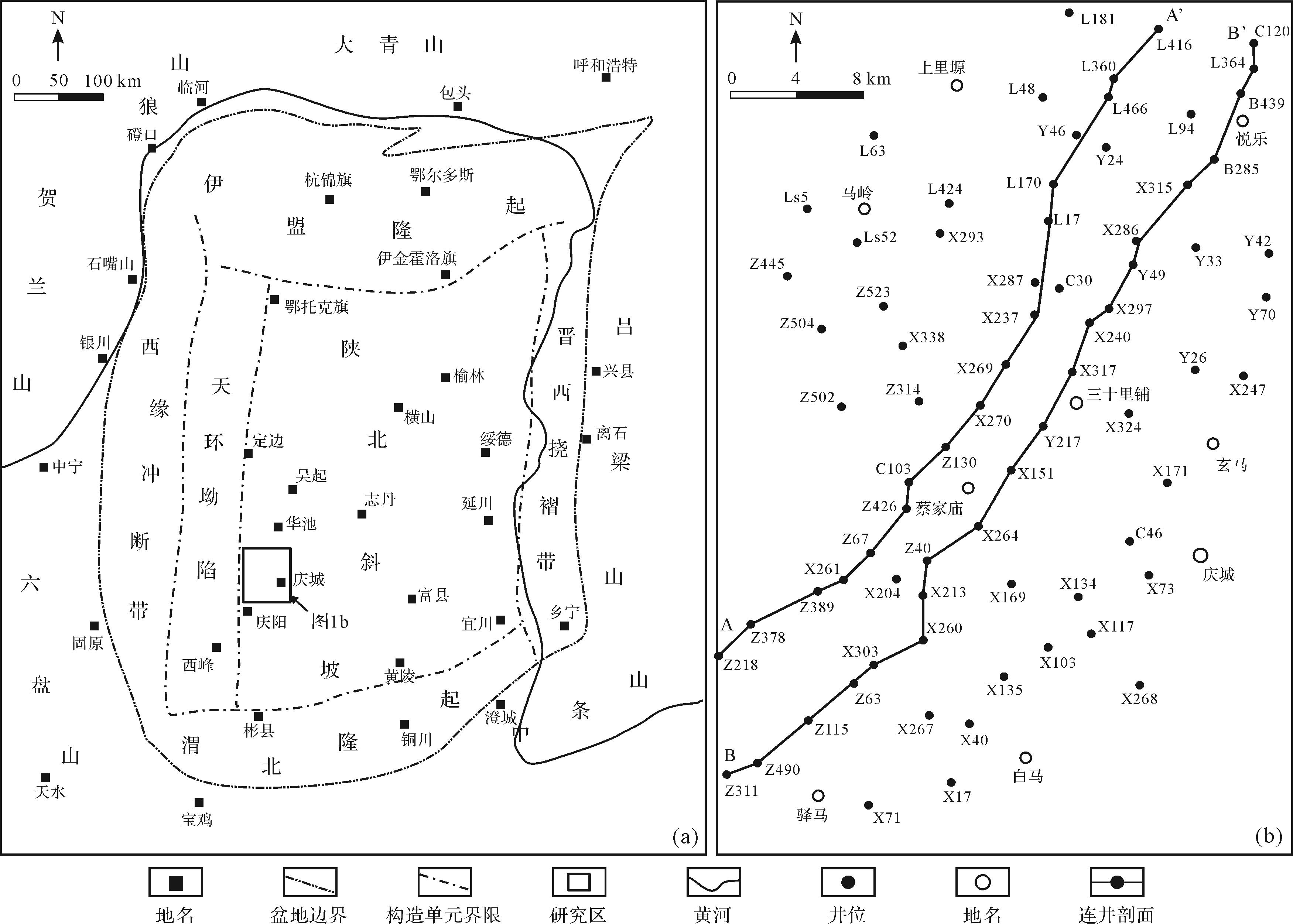
    勘探表明,盆地石油资源主要赋存于中南部地区的三叠系延长组[30],延长组沉积中心位于盆地中南部,呈北西—南东向展布,湖盆主要存在东北和西南两大沉积物源体系[3132]。其中,东北部距物源区较远,古地形较缓,沉积体系主要为曲流河三角洲[33]。研究区庆城地区处于盆地的西南部(图1a),主要接受来自秦岭的近物源供给,古地形较陡,多发育辫状河三角洲体系[3435]

    Figure 1.  Tectonic division of the Ordos Basin (a) and surveyed well distribution in the study area (b)

  • 本文运用沉积学、地震地层学和前积斜坡生长的基本理论,依托研究区1 800 km2三维地震资料及140余口钻井资料和岩心,结合前人建立的相关公式[3,8],定量表征延长组前积斜坡体的形态特征、坡折迁移特征等,对典型剖面进行井—震结合的砂体解释,分析不同斜坡生长方式下的砂体分布规律,通过三维地震属性提取和测井岩性解释,刻画各前积期次的砂体平面分布规律。结合物源供给、湖平面变化等讨论湖盆斜坡生长对砂体分布的控制作用。

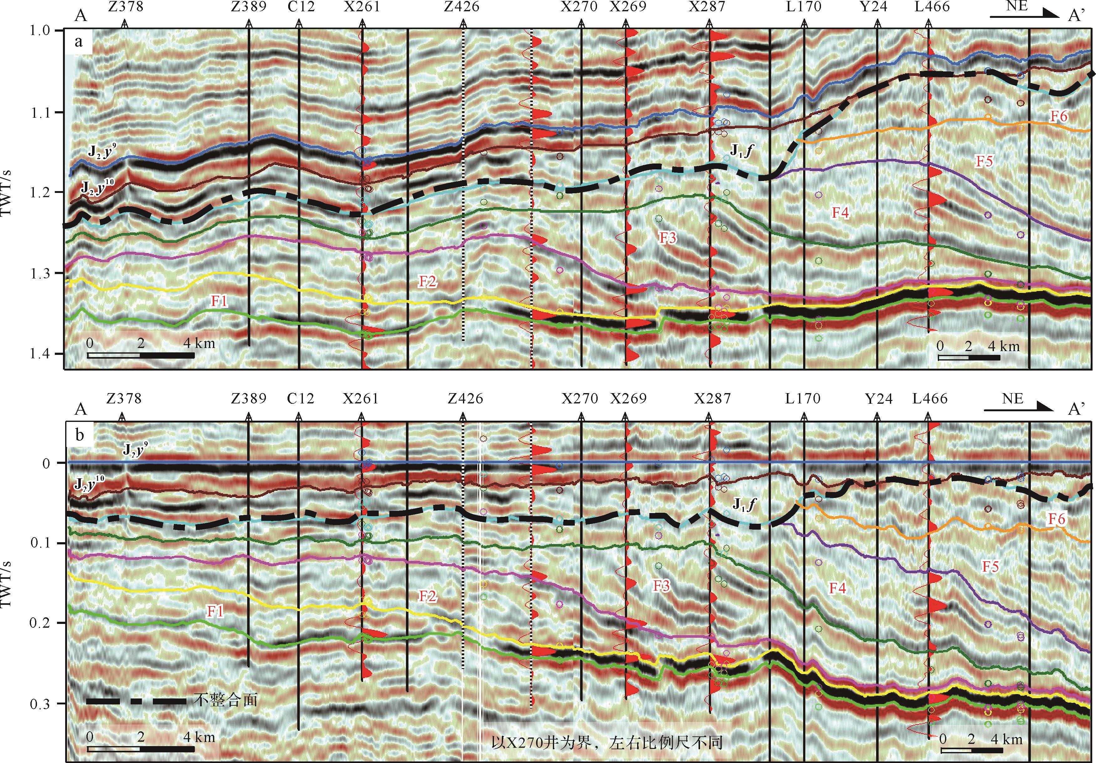
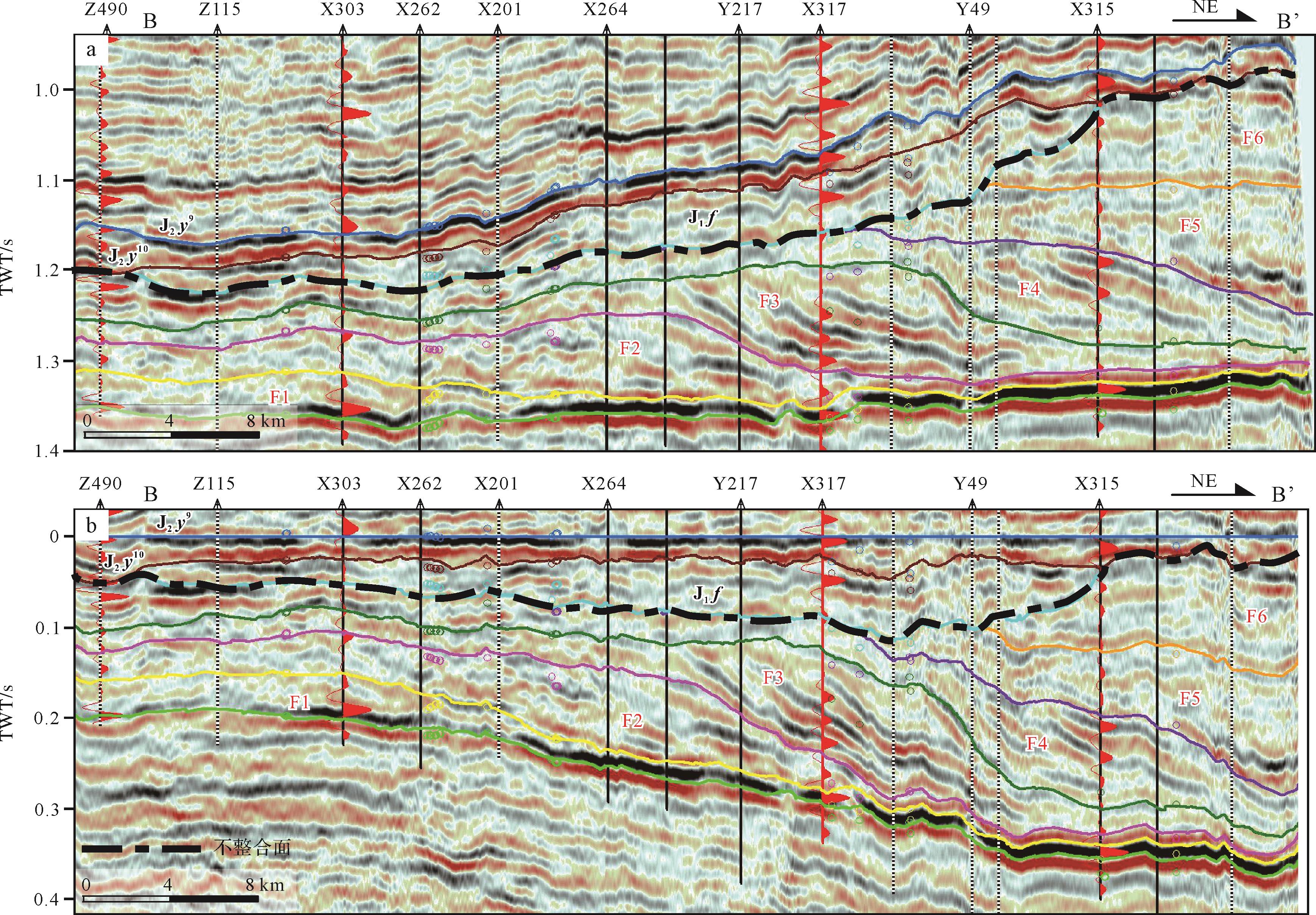
  • 结合井—震资料,对主干地震剖面进行斜坡期次划分,识别出延长组中上部主要发育6期前积斜坡体,依次命名为F1~F6(在冲积平原区与传统等厚分层基本一致),受印支运动抬升作用影响,F5~F6仅保留湖盆中心部位的沉积。晚三叠世末的印支运动,使该盆地发生短暂的抬升剥蚀改造,形成了起伏不平的古地貌,之后又填平补齐式地接受了侏罗纪沉积,造成三叠系延长组在盆地不同部位分别与富县组或延安组呈区域不整合接触[24]。鉴于鄂尔多斯盆地整体升降的演化特点,选取侏罗系延安组延9段标志性煤层作为基准面进行拉平处理,可基本消除富县组古河道对层拉平产生的影响,近似反映延长组各期沉积结束的基准面(图2b、图3b)。主要对保存较为完整的F1~F4斜坡体进行分析。

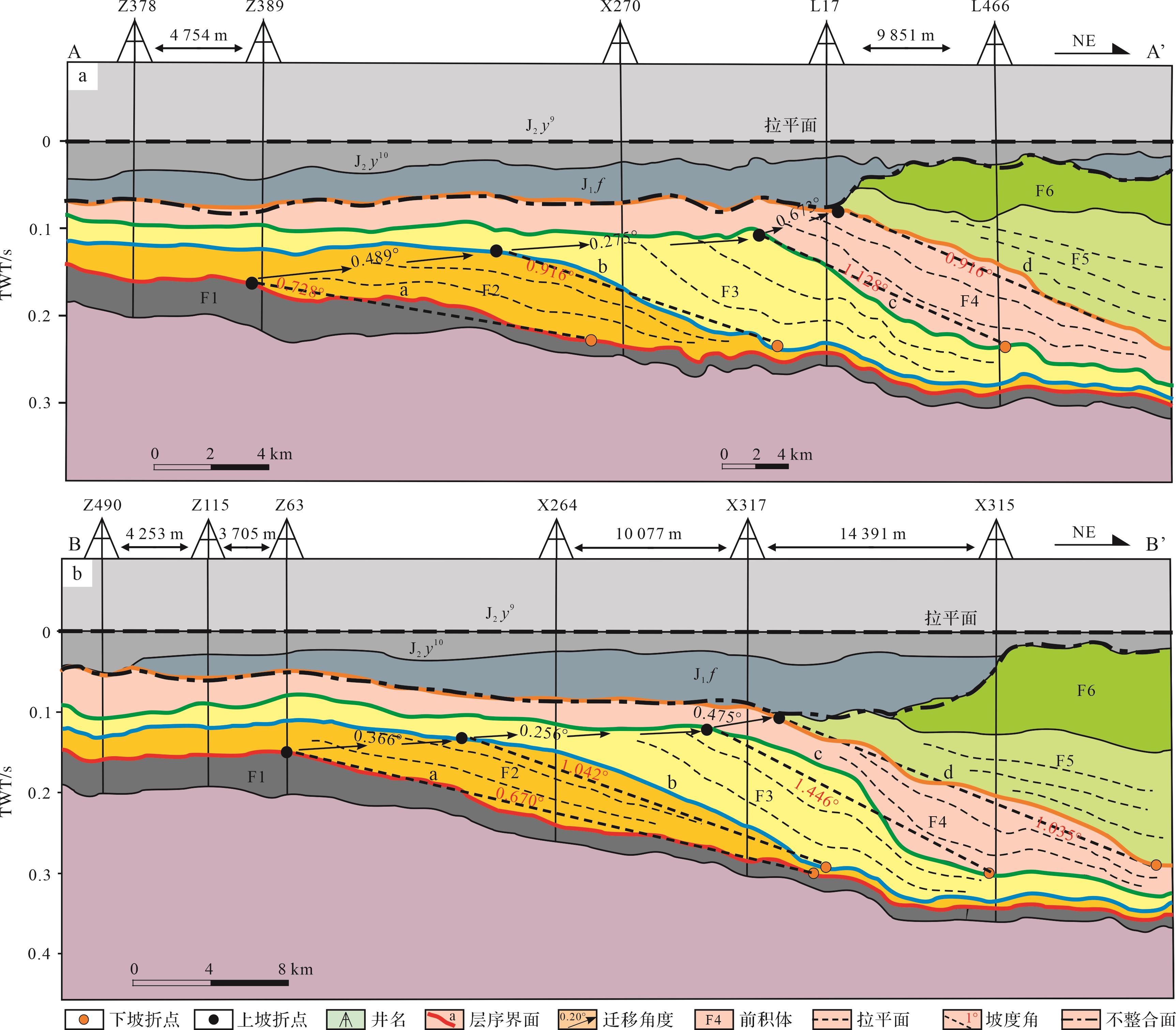
    Figure 2.  A⁃A' seismic section in the Qingcheng area, southwestern Ordos Basin

    Figure 3.  B⁃B' seismic section in the Qingcheng area, southwestern Ordos Basin

    研究区主要接受来自西南和南部的物源供应。从顺物源方向的地震剖面观察,F1~F4期斜坡体的外部形态相似,呈透镜状。4期斜坡体均具有完整的斜坡结构,发育厚度不一的顶积层、斜坡层和底积层。内部地震反射结构呈“S”型。

    斜坡分类常依据外部形态和内部反射结构[2021]。据上述特征,4期斜坡体可统一归类为透镜状“S”型。此外,也可依时间跨度进行斜坡分类。Johannessen et al.[9]认为,时间尺度上,斜坡可分为4个级别:4~6 My、1~2 My、100’s ky和10’s ky。依据项目内部资料,研究区Z389井及L14井的凝灰岩锆石定年数据,得到F1期地层最小年龄为235 My,F3期最小年龄为210 My。前人对长7油层组底部和上部的凝灰岩碎屑锆石定年数据显示,长7年龄介于221.8~228.2 My[36]。故单个斜坡沉积单元沉积时间大致为4~6 My尺度。

    为定量表征斜坡体结构,利用顶积层厚度与斜坡层厚度的比值,进行斜坡分类和表征。用“H/H”比值,反映地层相对厚薄。以厚度比值“1.00”为基准,比值大于1.00为“顶厚+斜薄”型,比值小于1.00为“顶薄+斜厚”型。据此将研究区内4期斜坡体分为两类(表1):“顶厚+斜薄”型(F1期)、“顶薄+斜厚”型(F2~F4期)。

    剖面名称期次H/mH/mH/mH/H(均值比)斜坡类型
    A—A’F1115~133120.25(116.5)42~10676.6(81)24~3229(29.5)1.569顶厚+斜薄
    F298~132119.25(123.5)51~187122.33(128)19~3526.5(26)0.975顶薄+斜厚
    F343~7557.71(59)119~248171.14(167)43~9770(70)0.337顶薄+斜厚
    F445~8268.83(71)132~227172.71(161)750.398顶薄+斜厚
    B—B’F178~11494.5(93)31~9553.1(47)20~3024(23)1.779顶厚+斜薄
    F259~9780.25(82.5)92~195147.28(133)20~4330.83(30)0.544顶薄+斜厚
    F360~9166.5(65)72~282182(162.5)50~6559(62)0.365顶薄+斜厚
    F466~10975.5(74)61~200153.33(167.5)610.492顶薄+斜厚
    注:115~133,表示地层厚度分布范围为115~133 m;120.25(116.5),表示地层平均厚度为120.25 m(地层中值厚度为116.5 m)。

    Table 1.  Clinothem thickness statistics in representative profiles in the Qingcheng area, southwestern Ordos Basin

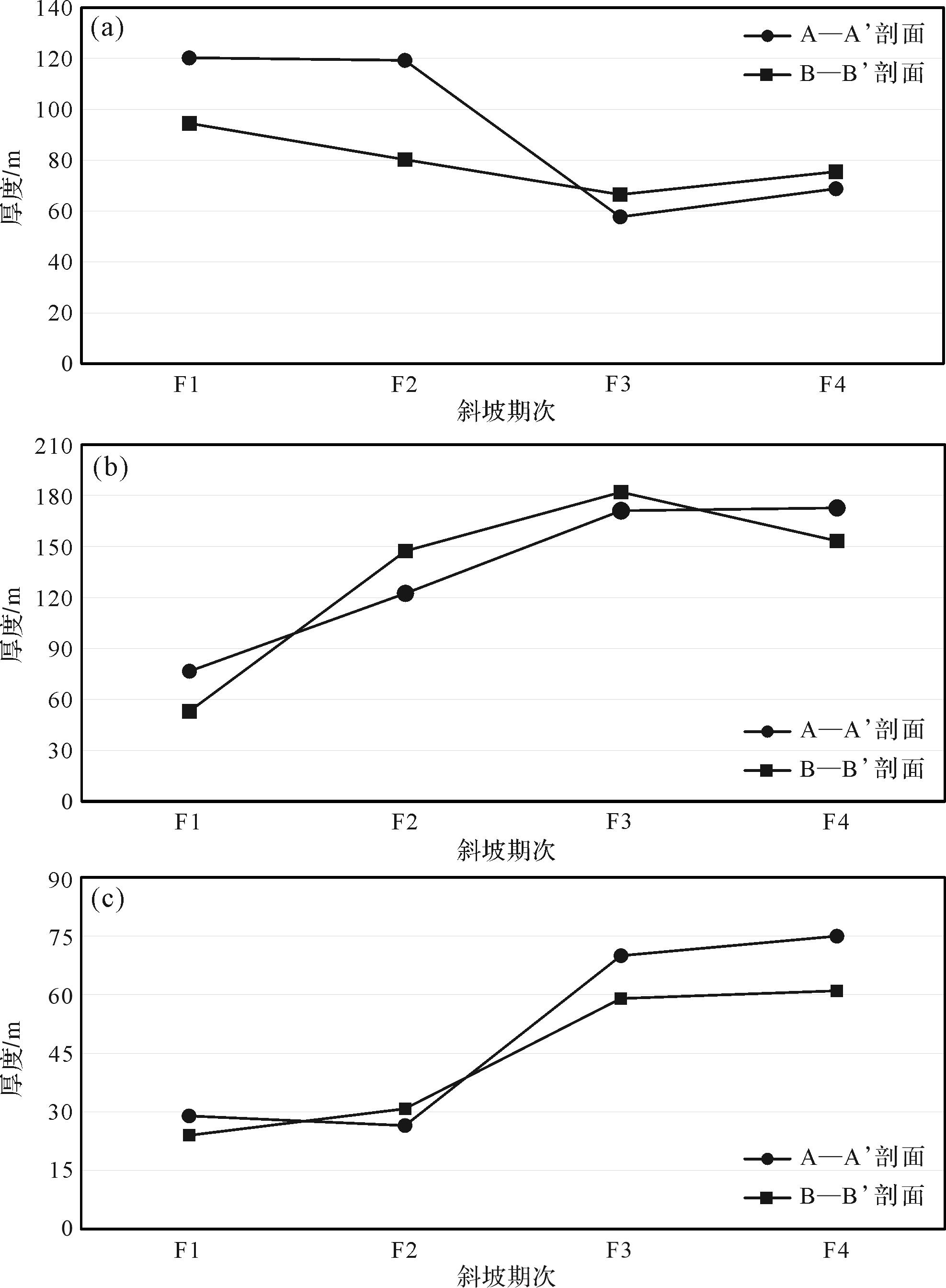
  • 斜坡体特征可依据其地层厚度、形态、坡度等进行描述。利用井—震结合剖面,统计相关几何参数(表1图4)。

    Figure 4.  Variation of average clinothem thickness from the Yanchang Formation in the Qingcheng area, southwestern Ordos Basin

    对研究区内顺物源的典型地震剖面分析表明,F1地层整体偏薄,其中顶积层稍厚,斜坡层和底积层较薄,为不对称“S”形态;顶积层呈中弱振幅—低连续反射,厚度介于90~120 m;斜坡层为中弱振幅—低连续反射,厚度介于40~80 m;底积层为中强振幅—高连续反射,厚度介于20~30 m。F2呈不对称“S”形态;顶积层为弱振幅—低连续反射,厚度介于80~110 m;斜坡层为中强振幅—中连续反射,厚度介于80~180 m;底积层为中强振幅—高连续反射,厚度介于20~40 m。

    F3、F4具有中间厚—两端薄的对称“S”形态。其中,F3期:顶积层为弱振幅—低连续反射,厚度介于50~70 m;斜坡层具有中强振幅—中高连续反射,厚度介于100~200 m;底积层为弱振幅—弱连续反射,厚度介于40~70 m。F4期:顶积层为中弱振幅—低连续反射,厚度介于50~90 m;斜坡层具有中强振幅—中高连续反射,厚度介于90~180 m;底积层厚度介于60~70 m。

    对比地层厚度及斜坡坡度(β)(表2),认为斜坡层厚度与形态具有相应变化规律。F1~F4期斜坡层厚度整体呈变厚趋势,在形态上,由不对称的“S”形态转变为对称“S”形态,在坡度上,呈整体变陡趋势。物源供给对斜坡的形成至关重要,而高速的物源供给易形成过路沉积,产生较陡的沉积坡度[4]。例如,F3期坡度较陡且沉积厚度较大,表明该时期物源较为充足。总体而言,从F1至F4期,沉积总厚度及坡度的变化趋势,表明物源供给量整体增加,供应速率逐渐变大,湖盆可容纳空间逐步减小。

    剖面名称期次迁移区间A/mP/kmA/(P×103迁移角度θ/(°)迁移类型斜坡体顶界面斜坡高度Rc/m顶界面斜坡段坡度β/°
    A—A’F1a1490.728
    F2a-b708.1850.008 50.489平坦b1810.916
    F3b-c6413.0740.004 80.275平坦c2851.128
    F4c-d473.9980.011 70.673低角上升d2540.916
    B—B’F1a3280.670
    F2a-b487.4890.006 40.366平坦b3411.042
    F3b-c6013.4210.004 40.256平坦c3991.446
    F4c-d303.6000.008 30.475低角上升d3881.035
    注:F1期斜坡未作迁移角度计算。

    Table 2.  Typical clinothem parameters used to describe shoreline trajectory in the Qingcheng area, southwestern Ordos Basin

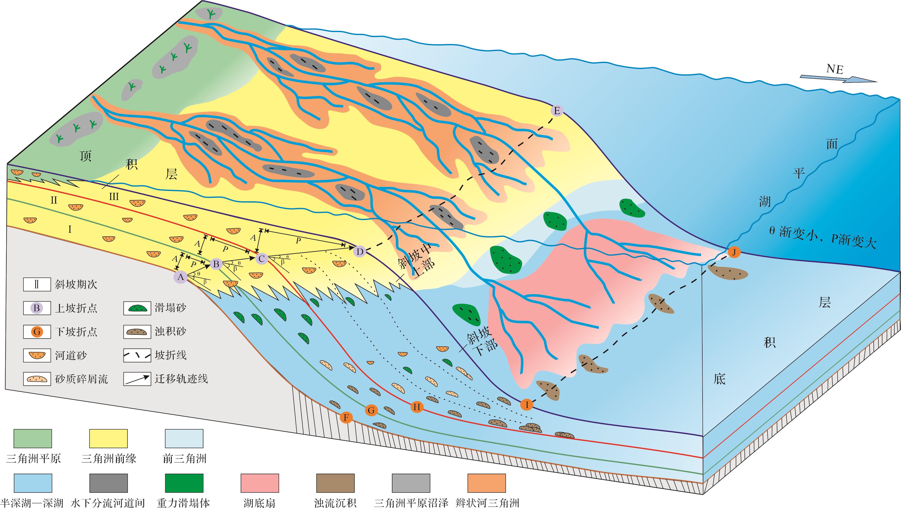
  • 为定量表征斜坡体特征及其生长方式,引入相关参数:(1)结构参数:斜坡高度(Rc,单位m)、斜坡坡度(β,单位°)、加积高度(A,单位m)、进积距离(P,单位km)、迁移角度(θ,单位°)、A/P值等;(2)物源供给参数:加积速率(Ra,单位m/My)、进积速率(Rp,单位km/My)和横断面的净沉积物通量(cross-sectional net sediment flux,Fc,单位km2/My)。

    斜坡结构参数几何意义如图5。物源供给参数计算公式如下[3738]

    Ra=A/T (1)
    Rp=P/T (2)
    Fc=Rp×A×10-3 (3)

    式中:T为时间尺度,单位为My。计算结果见下文表3

    剖面名称期次A/mP/kmRa/(m/My)Rp/(km/My)Fc/(km2/My)
    A—A’F1
    F2708.18517.502.0460.143
    F36413.07416.003.2680.209
    F4473.99811.750.9990.047
    B—B’F1
    F2487.48912.001.8720.090
    F36013.42115.0.3.3550.201
    F4303.6007.500.9000.027
    注:单个斜坡沉积时间跨度约为4 My。

    Table 3.  Statistics of sediment supply of individual clinothems in the Qingcheng area, southwestern Ordos Basin

    采用坡折迁移轨迹分析,研究斜坡生长与砂体分布之间的关系。其主要步骤为:(1)选取顺物源方向典型剖面,建立等时地层格架;(2)选取统一界面作拉平处理,识别坡折点的位置;(3)追踪坡折点的垂向、横向(向陆/湖盆方向)迁移轨迹,确定坡折迁移轨迹的类型(上升型、平坦型或下降型);(4)结合钻井取心、测井解释与地震资料,分析不同期次斜坡体对应的砂体发育特征。

  • 坡折迁移角度的变化能够反映物源供给变化、湖/海平面升降等信息[3,9,39]。在陆架斜坡的边缘迁移角度分类中,细分为高角度上升型迁移(大于2°)、低角度上升型迁移、平坦型和低角度下降型迁移[12]

    坡折迁移方向指示湖盆的沉积充填过程。进积式的迁移轨迹,表明湖盆演化是以向沉积中心的纵向推进为主导。通过坡折迁移轨迹参数计算(表2),可分为两类坡折迁移轨迹:低角度上升型(0.5°~1.0°)与平坦型(0°~0.5°)。其中F1顶界面a的坡折点为地形坡折点,处于深水沉积环境。F2迁移角度介于0.366°~0.489°,F3迁移角度介于0.256°~0.275°,均属于平坦型。根据岩心观察,F2、F3期坡折点附近沉积环境以三角洲前缘为主,F2、F3期坡折点为地形坡折点。F4迁移角度介于0.475°~0.673°,为低角度上升型。根据岩心观察,F4期坡折点西南方向发育炭屑、煤线等代表浅水沉积的三角洲平原亚相沉积,坡折点向北东方向主要发育三角洲前缘沉积。因此,F4期坡折点为滨岸坡折点。综合地层厚度(H/H)、迁移角度、A/P比值,认为F1具有“加积型”地层叠加样式,F2、F3则为“强进积型”,F4为“加积与进积混合型”。

    此外,比较斜坡坡度与迁移角度(图6),发现a、b、c、d四个界面的坡度呈现初始较缓,而后变陡,最后再变缓的变化特征。对应迁移角度表现出初始稍大,而后变小,最后再变大的趋势。平缓的迁移轨迹对应较陡的斜坡。F1沉积期,物源供应初始规模小,a界面的坡度受原始地形控制,物源因素影响小。F1沉积期之后,沉积物供应逐渐充足,物源对坡度的影响逐渐占主导,b、c、d界面整体变陡。由此推测,在较高物源供给速率影响下[5],具有平缓迁移轨迹的强进积型斜坡体,其斜坡坡度往往偏大。或因在平缓迁移轨迹下,多发生过路沉积,沉积物向湖心进积并堆积于斜坡区域,形成更陡的斜坡。较陡的坡度促进了重力流的形成,使得较多的砂质沉积物被搬运至深湖区。

    Figure 6.  Internal architectures of typical clinothems in the Qingcheng area, southwestern Ordos Basin

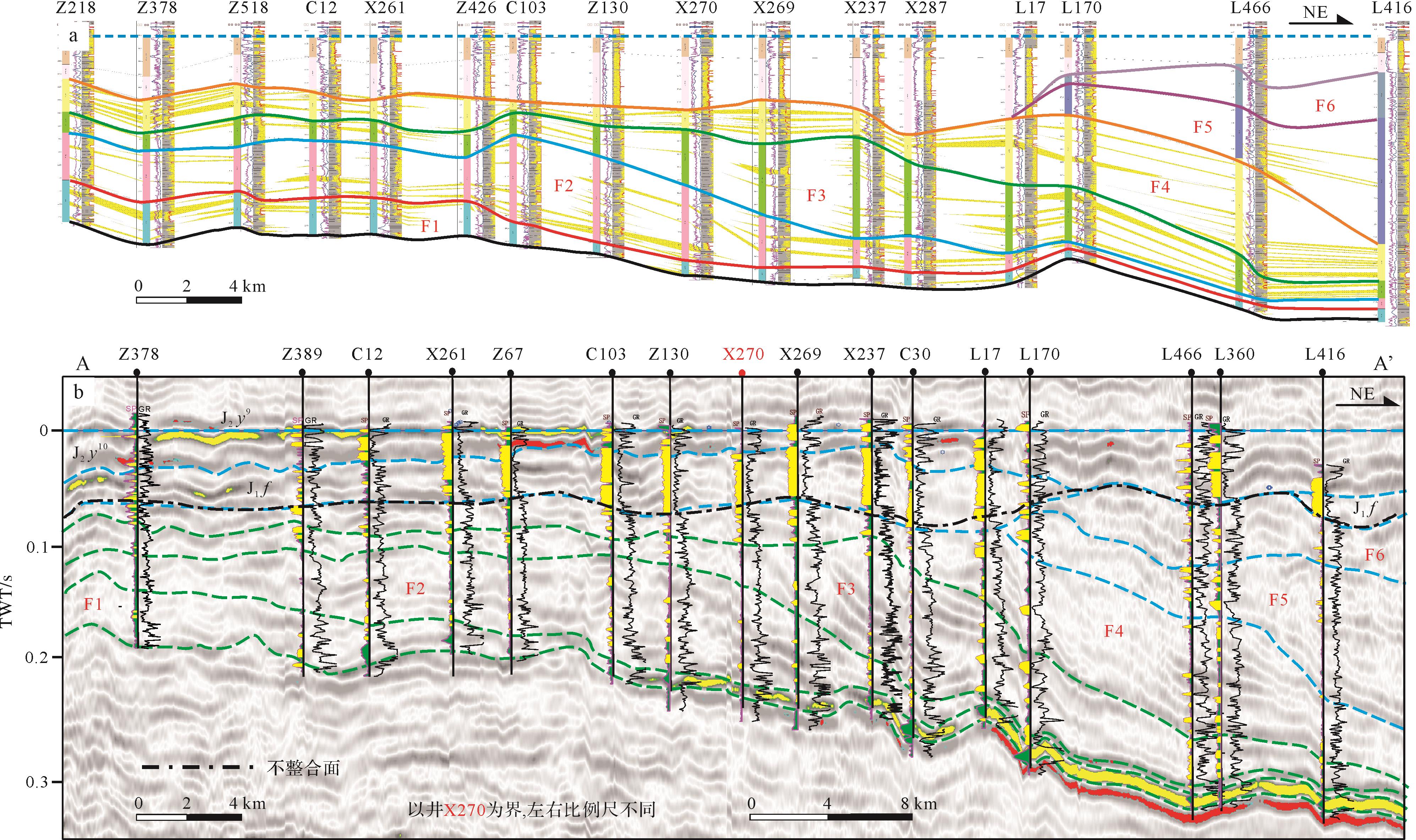
  • 为分析不同斜坡生长方式下砂体的剖面分布特征,结合地震、测井资料,建立砂体分布连井对比剖面(图7,8)。通过对典型剖面进行观察,总结F1~F4期斜坡体的砂体优势部位及其演变规律。

    Figure 7.  Interpreted sand bodies in the inter⁃well section of A⁃A’ (a) and corresponding well⁃seismic tied profile (b) in the Qingcheng area, southwestern Ordos Basin

    Figure 8.  Interpreted sand bodies in the inter⁃well section of B⁃B’ (a) and corresponding well⁃seismic tied profile (b) in the Qingcheng area, southwestern Ordos Basin

    由F1过渡至F4期,其砂体发育的优势部位不同,尤其在深水区分异明显,即斜坡层下半部和底积层砂体的不断变多。对比发现,F1期砂体多发育在顶积层和斜坡层上半部,底积层富泥;F2期,砂体富集于斜坡层,底积层、顶积层砂体较少;F3期,砂体多发育在斜坡层下半部、底积层,而较薄的顶积层中砂体较少;F4期,既含较丰富的顶积层砂体(浅湖区),亦有较丰富的斜坡层下半部及底积层砂体(深湖区)(图7,8)。

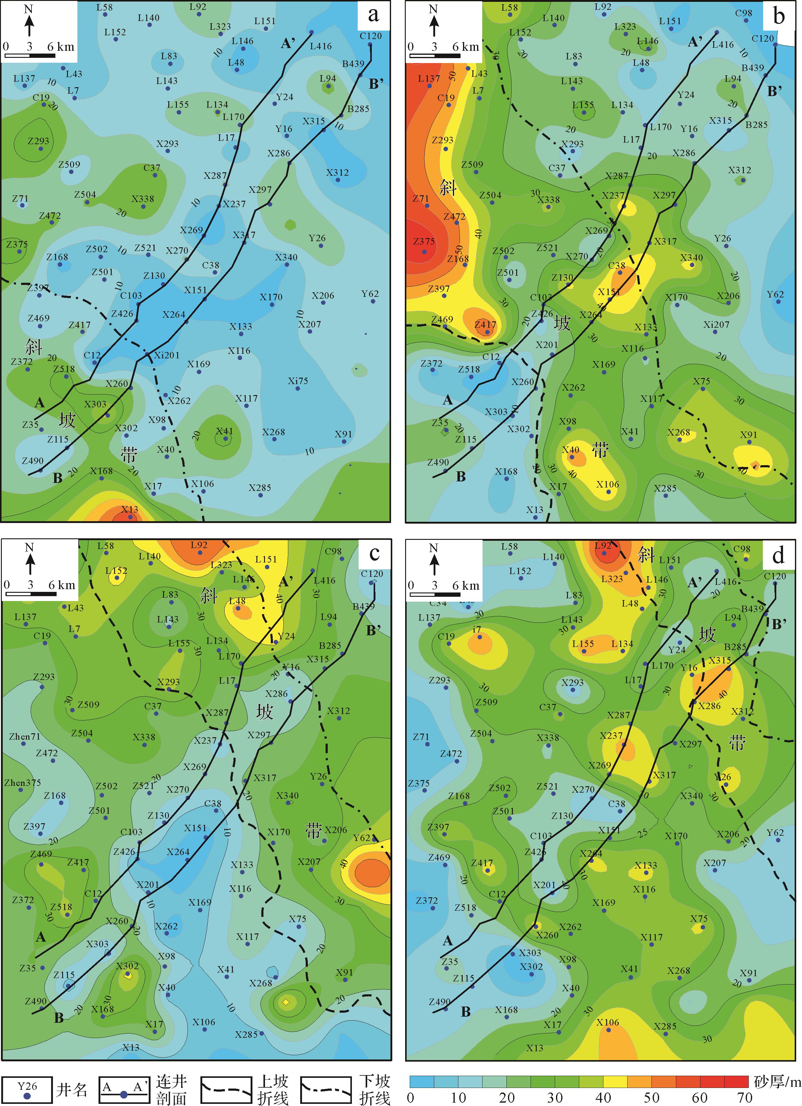
  • 为揭示各期斜坡沉积的砂体平面分布及其变化规律,依据地震和测井解释,编制了F1~F4沉积期的砂体厚度图(图9)。结果表明,随着斜坡体向湖盆中心的推进,砂体厚度分布样式发生规律性变化。

    Figure 9.  Sandstone clinothem isopach in the middle⁃upper part of Yanchang Formation in the Qingcheng area, southwestern Ordos Basin

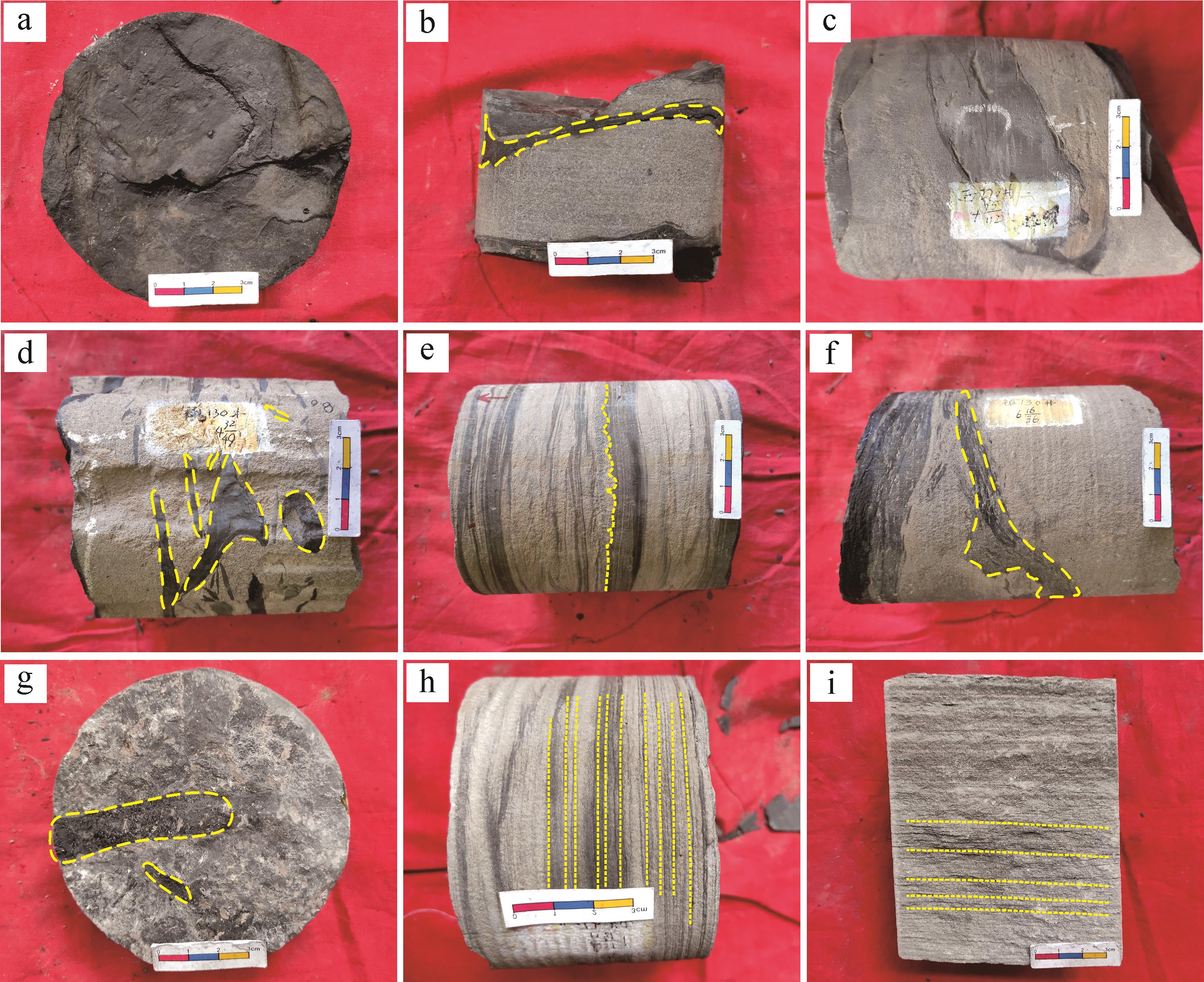
    F1沉积期,湖盆规模最大,此时物源供给相对不足,斜坡层砂体相对较厚,累计厚度介于20~30 m。岩心观察表明,该期斜坡的底积层砂体主要为重力流成因。受地震、重力等影响,斜坡层上部发生滑塌,并向深湖区继续搬运。深湖区重力流砂体厚度偏薄(图10b),厚0~15 m,呈条带状展布。

    Figure 10.  Typical core pictures of the clinothem topsets, foresets, and bottomsets in the Qingcheng area, southwestern Ordos Basin

    F2~F3沉积期,湖盆转变为过补偿沉积。坡折带之上的顶积层砂体渐多,砂体厚40~50 m,多为三角洲前缘砂。在物源充足的背景下,砂体经坡折带搬运至半深湖—深湖区,坡折带以下的砂体增多,厚度加大,其中斜坡层砂体厚度可达40 m。由于沉积物不断累积以及较陡的坡度,重力流沉积广泛发育(图10d)。过渡到湖盆中心处,底积层砂体薄,厚度介于0~10 m。

    湖盆发展到F4沉积期,三角洲持续向湖盆中心进积,三角洲前缘沉积(图10h)范围更广,砂体也进一步向研究区东北方向推进。总体而言,F1砂体多分布于研究区西南部,F2、F3、F4砂体逐渐向研究区中部和东北部深湖区聚集。

  • 斜坡生长方式具体表现为斜坡体的形态、迁移轨迹等方面。基于前文斜坡形态及迁移轨迹的分析,总结斜坡生长方式与砂体分布的关系。F1为加积型斜坡,具“顶厚+斜薄”特征,砂体多发育于斜坡体中上部。F2~F3为进积型斜坡,呈“顶薄+斜厚”特征,具有平坦型轨迹,斜坡层下半部富砂。F4为加积—进积混合型斜坡,具有低角度上升型轨迹,顶积层及斜坡层下半部富砂。由此认为,随着加积型斜坡转变为进积型斜坡(F1~F3)以及迁移角度的降低(F2~F3),砂体逐渐富集于深湖区(斜坡层下半部及底积层)。迁移角度的增加(F4)会提高加积高度,顶积层的砂体厚度因此增大。

    此外,需要考虑迁移角度的增加对深湖区砂体的影响。研究区F4迁移角度比F2、F3有所增大,其深湖区砂体仍较丰富。造成这一现象的原因或为:(1)湖盆规模小且距源区更近,物源供给较充足;(2)湖平面上升快而周期短,形成的迁移角度较低(仍小于1°);(3)F4沉积期已进入湖盆演化末期,湖平面上升所增加的可容纳空间有限。因此,分析迁移角度变化与砂体分布的联系,需要综合物源、湖平面、湖盆演化阶段等因素。

  • 控制斜坡生长方式及深湖区砂体分布的因素主要有物源、湖平面变化、气候等[45,9,1214,18]。由于延长组整体的气候为温暖湿润环境,故气候因素并非造成延长组中上部前积斜坡差异性生长的主要因素。

  • 在各个斜坡沉积期,其物源供给量不同。F1~F4期,物源供给表现为少量低速—大量高速—相对降速的变化过程(表3)。

    F1沉积厚度较其他3期薄(表4),反映F1处于欠补偿沉积期,A/S值大于1,为高可容纳空间阶段。此阶段,形成加积型斜坡,砂体主要发育在顶积层,而深湖区富泥质沉积。F1沉积期之后,物源供应通量增加,湖盆由欠补偿沉积过渡为过补偿沉积,A/S值开始减小。在强物源供应背景下,进积速率增加,产生低角度上升型轨迹,形成进积型斜坡。其中,F3沉积期的进积速率与净沉积物通量处于高峰,形成平坦型轨迹,深湖区砂体富集程度远超F1期。因此,物源供给对研究区的斜坡生长及砂体分布具有主导作用。高物源供给通量与高供给速率,是深湖区砂体富集的重要因素。

    剖面名称期次H/mH/mH/m总厚度/m总沉积速率/(m/My)
    A—A’F1120.2576.6029.00225.8556.46
    F2119.25122.3326.50268.0867.02
    F357.71171.1470.00298.8574.71
    F468.83172.7175.00316.5479.13
    B—B’F194.5053.1024.00171.6042.90
    F280.25147.2830.83258.3664.59
    F366.50182.0059.00307.5076.87
    F475.50153.3361.00289.8372.45
    注:单个斜坡沉积时间跨度约为4 My。

    Table 4.  Average thickness and sedimentation rate of individual clinothems in the Qingcheng area, southwestern Ordos Basin

  • 湖平面的升降影响湖盆可容纳空间的变化,控制湖盆斜坡的生长方式,调节沉积物的分散样式。水位变化幅度与进积速率(或物源供给速率)共同控制斜坡的形态[4043]

    综合前人研究[22,2728]及迁移轨迹分析,认为在湖退背景下,湖平面有多期短暂上升,但湖盆可容纳空间整体减小。在水体规模最大而物源供应弱时(F1沉积期),斜坡沉积速率较低,以加积式沉积为主。当湖平面下降而物源供给增强时(F2~F3沉积期),加积速率降低,进积速率增加,深湖区砂体变多。在物源供应整体稳定时(F4沉积期),湖平面上升,则加积速率增大而进积速率减小。因此,随着湖平面整体下降,研究区湖盆斜坡由加积型转变为进积型,迁移角度整体偏低,深湖区逐渐成为砂体重要富集场所。

    基于前文斜坡形态、迁移轨迹以及物源供应等分析,认为研究区延长组斜坡生长方式及其砂体分布主要受控于物源供给与湖平面变化两大因素。随着物源逐渐充足以及整体性湖退,深湖区砂体由贫乏转为丰富(图11)。在低物源供给与高湖平面(高可容纳空间)影响下,斜坡进积速率低,深湖区砂体少。然而,在高物源供给及湖退(可容纳空间减小)的背景下,进积速率高,深湖区富砂。因此,高物源供给及湖平面下降是深湖区富砂的重要因素。

    Figure 11.  Sandstone depositional mode in response to the different types of shoreline trajectories

    综上所述,在湖盆演化的F1~F4沉积期,斜坡体以进积方式向沉积中心推进,砂体被携带至湖盆深水区域,呈现出砂体向东北深湖区不断推进、分布范围扩大的趋势。F4沉积期之后进入湖盆演化晚期,则主要为垂向加积式的充填过程。

  • (1) 庆城地区延长组中上部存在斜坡生长现象,划分出F1~F4共4期发育较完整的斜坡体,4期斜坡体呈透镜状“S”形态。依据“H/H”比值,分为“顶厚+斜薄”型(F1期,H比值大于1)和“顶薄+斜厚”型(F2~F4期,H比值小于1)两类。

    (2) F2、F3期的迁移轨迹为平坦型,F4期为低角度上升型。上升型迁移轨迹表明湖盆在整体湖退背景下,发生短期湖平面上升事件。3期迁移轨迹向湖盆中心推进,表明湖盆以进积方式充填。基于迁移轨迹与地层厚度,认为F1为“加积型”斜坡,F2、F3为“强进积型”斜坡,F4为“加积与进积混合型”斜坡。

    (3) 物源供给与湖平面变化是研究区斜坡生长及砂体分布的主控因素。低沉积物供给与高湖平面背景下,多形成加积型斜坡,具有上升型迁移轨迹,砂体多发育于顶积层和斜坡层上半部;高沉积物供给与湖退背景下,形成进积型斜坡,具有平坦型或低角度上升型迁移轨迹,砂体多发育于斜坡层下半部、底积层。研究区F1~F4期的砂体,平面分布上表现为由西南向东北推进且分布变广的趋势,剖面上呈现向深湖区的斜坡层和底积层聚集的趋势。

Reference (43)

Catalog

    /

    DownLoad:  Full-Size Img  PowerPoint
    Return
    Return